Lake Level Monitoring
What is the lake level monitoring program?
The Discovery Center, with the assistance of the UW Trout Lake Research Station in Boulder Junction, hosts the largest and longest running effort in Wisconsin to monitor lake water levels. The project has monitored about 40 lakes for over 7 years, creating a unique data set used by scientists to create predictive models. UW Trout Lake and Wisconsin DNR scientists are using these data to predict effects of precipitation on lake levels, and to predict effects of changing lake levels on ground water flow.
Lake level monitoring must be a long-term, multi-year effort in order to accurately discern trends and patterns. Our efforts depend heavily on the riparian owners who monitor their lakes each week, and the specialized volunteers who assist with gauge installation and removal. The lake level monitoring project utilizes over 50 volunteers.
How does lake level monitoring work?
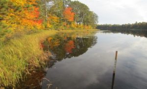
One-meter staff gauges are mounted on metal fence posts. They are installed into lakes in the spring after ice-off, and removed before ice-on on the fall. Using land survey techniques, specialized volunteers reference each staff gauge to a permanent, fixed benchmark on the shoreline. This allows for us to compare lake levels from year to year. Riparian owners read staff gauges each week to the nearest 0.5 centimeter.
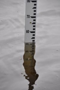
Close-up view of a lake gauge
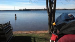
Calibrating lake gauges to fixed bench marks so that data can be compared from year to year
What are some ways the data have been used?
University of Wisconsin scientists published an article in 2014 indicating that “lakes in the upper Great Lakes region of North America have been dominated by a climatically drive, near decadal oscillation for at least 70 years.” The oscillations are consistent among small seepage lakes (meaning the lakes do not have incoming our outgoing rivers/streams), groundwater tables, and the two largest Great Lakes. These levels are all related to measures of precipitation.
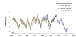
Graph from Watras et al. 2014. The left axis, “Anomaly,” can be thought of as change in water levels, and the bottom axis is time in years. Note that the trend lines for two lakes (both in the Northern Highland region), and the local and regional ground water levels all display similar trends over time.
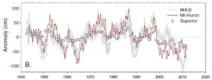
Graph from Watras et al. 2014 showing the changes in water levels over time for the Northern Highlands region, Lake Michigan-Huron, and Lake Superior. Note that while Lake Superior’s trend may be more subtle, all water bodies follow similar trends over time.
Is my lake monitored?
You might not even be aware your lake is part of our project! Take a look at the list below to see if your lake is being monitored. Contact our Water Program Coordinator if you are interested in seeing data from any of the lakes listed below.
All lakes are located in Vilas County, WI
Annabelle Lake (monitored since 2010)
Armour Lake (monitored since 2010)
Birch Lake (monitored since 2010)
Van Vliet Lake (monitored since 2010)
Crab Lake (monitored since 2010)
Wildcat Lake (monitored since 2010)
Horsehead Lake (monitored since 2010)
Presque Isle Lake (monitored since 2010)
Rainbow Lake (monitored since 2010)
Oxbow Lake (monitored since 2010)
Pardee Lake (monitored since 2010)
Tamarack Lake (monitored since 2017)
Papoose Lake (monitored since 2010)
Katinka Lake (monitored since 2010)
Hiawatha Lake (monitored since 2010)
Statehouse Lake (monitored since 2010)
Carlin Lake (monitored since 2008)
Little Rock Lake (monitored since (2008)
Imogene Lake (monitored since 2011)
Dewey Lake (monitored from 2011-2012)
Rosalind Lake (monitored since 2011)
Smoky Lake (monitored since 2012)
Red Bass Lake (monitored since 2014)
Lynx Lake (monitored since 2016)
Harris Lake (monitored since 2016)
Flambeau, White Sand, Fence, Little Crawling Stone, Pokegama, Ike Walton, Middle Sugarbush, and Wild Rice Lakes are all monitored by the Lac du Flambeau Tribal Natural Resources Department.
Interested in learning more? Contact our Water Program Coordinator for more information.
Your Help Is Needed
Curly leaf pondweed has been found in the Manitowish Waters Chain. Please keep your eyes open and let us know if you see this aquatic invasive plant along your shorelines or docks. Additionally, please check your boats and props to prevent the spread!
Citizen AIS Lake Monitoring
Join a crew to search for suspicious-looking species (plant or animal). Keep your eyes peeled and report any sightings to us.
Clean Boats Clean Waters
Educate boaters at landings and inspect boats and trailers.
Volunteer today, to protect our waters tomorrow.
Email: water@discoverycenter.net
Phone: (715) 543-2085
AIS of the Month
September: Mystery Snails
August: Eurasian Water Milfoil
July: Purple Loosestrife
June: Curly Leaf Pondweed